Outdated features and industry demand
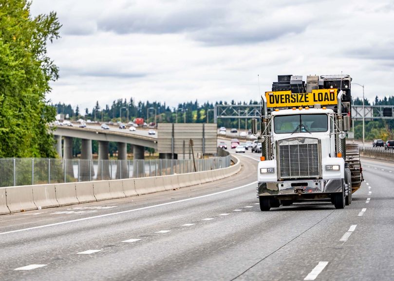
A State Department of Transportation (DOT) client is responsible for issuing permits for all oversize/overweight (OS/OW) trucks traveling on state-owned roads. A central permitting office manages these activities, which are supported by an automated permit routing and analysis system and knowledgeable staff across multiple district offices.
The legacy system built on mainframe COBOL went live in 1998 and issued over 400,000 oversize/overweight hauling permits every year. Despite its prolonged existence over 20 years, state and industry users acknowledged that the existing system was unable to provide the modern tools in demand by internal and external users. It was time to implement a solution with new functions and features, such as map-based routing, to improve the user experience.
Time-consuming and costly legacy operations
The legacy system was challenging and frustrating to use and would often require rework (and extra work) by internal and external users:
- Limited useability: Modern route-driven permit systems provide visual tools. Because the legacy system lacked a visual mapping feature, hauling industry end users still referenced paper maps to find road names and turns and select their desired route using unfriendly dropdown menus. This was very time-consuming. Plus, with no frontend analysis or route visibility, the process was prone to frequent data entry and routing errors resulting in multiple attempts and rejected applications. Frequently, haulers had to call the agency and request assistance just to find a permittable route.
- Costly maintenance: Like many legacy solutions, the outdated architecture, code tools, and data constraints meant costly maintenance, a limited ability to make enhancements, and impacts to state staff time.
- Security risks: The legacy solution still used old-style, in-application security instead of the agency’s modern security solution.
- Restricted scalability: The agency wanted to futureproof their permitting system and plan for increased demand. They also wanted to locate the new solution in the cloud.
- Impacts and challenges: Slow route entry with no guidance often left hauling companies with un-permitted loads unable to move. Agency staff would spend a large amount of time helping struggling haulers find a permittable route, get it entered into the legacy solution, and successfully avoid enough errors to get an application submitted. Training agency staff and industry end users was also time-consuming.
The agency initially wanted to implement a commercial off-the-shelf (COTS) solution. However, the COTS solution was unable to work with the agency’s existing architecture and data. Following a multi-year attempt, the agency was still in need of a modern solution and decided a custom solution would be easier to align with the existing infrastructure and data, and it would be more cost effective to support, simple to use, and maintainable as requirements changed over the years.
Modernizing while incorporating industry needs
CAI partnered with the state to develop a modern version of APRAS (Automated Permit Routing and Analysis System) over two phases. The first phase of the approach would create a modern external interface to integrate into the legacy backend, and the second phase would replace the entire legacy backend.
The OS/OW hauling industry leaders were a driving force behind the urge to modernize. CAI and the client knew modernizing a legacy application provided a once-in-a-many-decades opportunity to completely overhaul the user interface/experience (UI/UX) and accommodate current and future industry and agency needs. To make this happen, CAI and agency staff closely collaborated with external hauling company end users as well as internal staff. This included site visits to observe industry experts use the legacy system and learn about the many aspects of hauling OS/OW loads. This included insights into the engineering of load-hauling, how they determined the weight distribution over multiple axles, and how they planned their routes.
Together, the CAI project and agency team members explored existing challenges and functional requirements from all angles and applied these observations to the application development approach. When the first phase was ready for deployment to production during the earliest days of the COVID-19 pandemic, CAI developed a gradual rollout plan that started with a small pilot group of industry specialists. The pilot effort provided training and in-person oversight to capture any issues and answer any questions. After a successful pilot, the modernized application frontend was made available to all industry users.
A key contribution to the success of the modern frontend was the addition of map views and automated routing supported by ESRI geospatial solutions and agency data. Designed to align with hauling industry best practices, users can simply plot start and end points on a map feature that automates and visualizes the route options while considering truck dimensions, load weights, axle weights, roadway hazards, bridge heights, and more to chart the safest route. Users can even adjust the route and add waypoints to customize the trip.
Saving everyone time and money
Following the launch of the modern external APRAS interface, the agency and hauling end users experienced several positive outcomes, including:
External users are feeling the improvements in their workloads and appreciate the enhanced usability.
“The State system, in my opinion, and the opinion of my coworkers, [is] our favorite system to work with. We are saving time on applications, and time is money. … We are much more knowledgeable on route restrictions, the home page has a nice map, and it's marked in yellow or red if there are any type of restrictions. You just click on it and there it is. …. If I had to describe the system in one way, it just flows much better. It's not overwhelming. It's pleasing to the eye. A new user who has relatively little experience applying for permits, can go through that system, and probably get a permit with minimal instruction.”
To learn more about our end-user-informed approach to solution development intended to benefit all system stakeholders, how we create GIS-powered solutions, or CAI’s experience in the transportation and tolls industries, start a conversation with us.